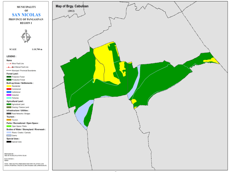
BARANGAY CABULOAN
BRIEF SOCIO-ECONOMIC PROFILE
Cabuloan was formerly a sitio of Barrio Sto. Tomas before the 60’s. The PACD creation of barangays in the countrysides made local leaders respond to the call of the times that cabuloan became a distinct and a separate barangay. It is one of the barangays which comprises the 5-C barangays of the Sto. TomasCentro. It is bounded on the south by the Sabangan River and Brgy. San Rafael
Centro, Sitio Casapangan; on the east by Brgy.Camangaan; on the north by Brgy.Sto.Tomas and on the west by the Agno River.
According to old folks, Cabuloan got its name from the root word “bulo” which in Pangasinan language refers to a species of bamboo. Thus, the word Cabuloan means the place where the “bulo” is generally found. The bulo is a special kind of bamboo but unlike “kawayan”, it does not grow everywhere. It is highly useful not only as a housing material but as a handicraft material like in basket making sawali and bilao because of the thinness. Due to the abundance of bulo growing at the place, the people named the place Cabuloan. Up to the present, bulo is still predominantly growing in Cabuloan.
Endowed with a shallow water table, water simply ozze out as springs from the ground even on hot summer months in cabuloan. This had made agriculture and fishpond raising very productive to local folks. Similarly blessed by nature with rich and fertile soil, good
irrigation and hardworking people, farming had become the primary source of income of the inhabitants. Other sources of income are fishing, fishpond raising, pottery making, livestock raising and bamboo craft. Its main farm produce are palay, corn, and vegetables.
Some local leaders became prominent leader of the municipality like former councilors Don Cecilio Doton and Don Florentino Lampa. The latter is the father of incumbent Councilor Filipina T. Lampa, whom like his father is a native of Brgy. Cabuloan.Prominent families of Brgy. Cabuloan are the Doton, Arquero, Lampa, Rodrigo and Seriosa among others.
Boundaries :
North: Brgy. Camangaan South : Brgy. San Rafael Centro
East : Brgy. San Rafael West West : Brgy. Sto. Tomas
Distance from Poblacion (kms.) : 5.5 km
Road Type : Gravel, Concrete
Seasons :
Dry – December to April
Wet – May to November
Average Annual Rainfall (mm.) 147.21 mm
Average Monthly Temperature (Celsius) 29.15°C
Status of Land classification (has.):
Existing Land Uses | Area (has.) |
Agricultural Land | 82.298 |
Sabangan River | 6.603 |
Residential | 15.983 |
Fisheries | 0.020 |
Cannals | 0.322 |
Road Networks | 0.484 |
Total Land Area | 105.709 |
Major River : Sabangan River
Soil Type : Umingan Sandy Loam
SOCIAL PROFILE
Social Profile | |
Total Pop. (NSO 2020) | 919 |
Annual Growth Rate | 5.75 |
Pop. Density | 9 |
No. of Households (CBMS 2020) | 234 |
Ave. Household Size | 5 |
Sex Ratio (Male/Female) | 91:100 |
Public Buildings / Facilities | |
Barangay Hall | 1 |
Elementary School | |
High School | |
Brgy. Health Station | |
Brgy. Health Center | |
OSCA Building | |
Brgy. Daycare Center | 1 |
Church | ü Catholic ü Iglesia ni Cristo |
Brgy. Cemetery | |
ECONOMIC SECTOR
Economic Sector | |
Agricultural Production | corn, palay, vegetable |
Livestock/Poultry Production |
|
Existing Industries |
|
Tourist Attractions |
|
INFRASTRUCTURE AND UTILITIES
Infrastructure and Utilities | |
Transportation | motorcycle, tricycle |
Telecommunications | sun, globe, smart |
Postal Communication |
|
Power and Electrification | PANELCO III |
Water Supply and Irrigation |
|
Potable Water Supply | Level I |
Post Harvest Facilities |
|
Slaughterhouse |
|
Market |
|
BARANGAY OFFICIALS:
BARANGAY OFFICIALS | ||
Position | Name | |
Punong Barangay | STEVE RODRIGO CABACUNGAN | |
SBM 1 | DENNIS TALINGA DOTON | |
SBM 2 | ROBERTO BALAISN AGMATA | |
SBM 3 | JOSELITO DOTON ESPIRITU | |
SBM 4 | SATURNINO CASER PARAGUAS | |
SBM 5 | ALEXANDER MARELO PASCUA | |
SBM 6 | JOVENCIO TALINGA DOTON | |
SBM 7 | ROMEO VIRAY BANSIL | |
SK Chairperson |
| JOEBERT MIANA ROQUE |
Barangay Secretary | MARY FE A. DOTON | |
Barangay Treasurer | FERMINA R. QUESADA | |

