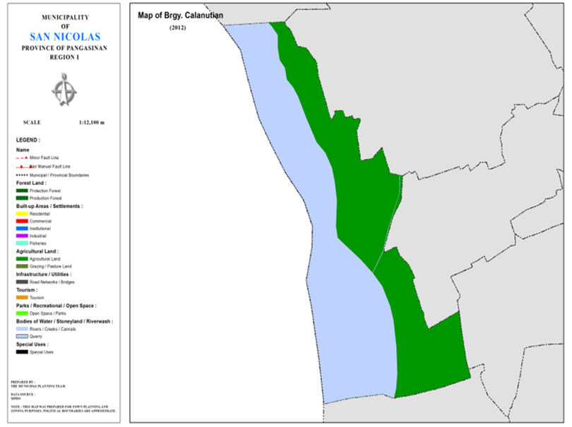
BARANGAY CALANUTIAN
BRIEF SOCIO-ECONOMIC PROFILE
Calanutian is the only island barangay of San Nicolas situated west of the town some 8 kilometers away and isolated by Agno River that provide most of the water supplies needed to irrigate the ricelands in Eastern pangasinan.
Just like most of the barangays in San Nicolas, Calanutian was inhabited by settlers from Ilocos Sur and La Union. It was a part of Barrio Sto. Tomas that encompassed Cabuloan, Camanggaan and Centro and Camindoroan. Prominent among the migrants were the Aquino, Cabonitalla, Ortiguero and the Lucas clans.
The place was grown by thick forest, one of which was the “lanuti” which was found everywhere and even in river banks. Agno river then was blessed with crystal clear water teeming with delicious fish of many kinds. Picnickers frolicked on its white sands during summertime and sought shelter under the shades of robust lanuti trees.
The lanuti rivers became popular that soon people from far and wide called the place “calanutian” or a place where the lanuti trees were in great abundance.
A flash flood in the 70s caused by a strong typhoon swept away the big parcel of lands in this barangay. Because of this, they decided to settle in a vast ricelands across the Agno River near Sitio Pugo of Barangay. San Felipe West, They now called the place Villa Jose in honor of former Barangay Captain Jose Paragas, who served the Barangay for more than a decade before he died.
Boundaries :
North: Brgy. San Felipe West South : Brgy. San Rafael West
East : Brgys. Camindoroan, West : Mun. San Manuel Pang. Sto. Tomas, Cabuloan, Cabuloan
Distance from Poblacion (kms.) : 5 km
Road Type : Earth
Seasons :
Dry
– December to April
Wet – May to
November
Average Annual
Rainfall (mm.) 147.21 mm
Average Monthly
Temperature (Celsius) 29.15°C
Status of Land classification (has.):
Existing Land Uses | Area (has.) |
Agricultural Land | 69.408 |
Agno River | 81.597 |
Residential (Resettlement at Brgy. San | (7.12) |
Cannals | 0.050 |
Total Land Area | 151.056 |
Major River : Agno River
Soil Type : Umingan Sandy Loam, Pangasinan River Sand
SOCIAL PROFILE
Social Profile | |
Total Pop. (NSO 2020) | 590 |
Annual Growth Rate | 0.42 |
Pop. Density | 3 |
No. of Households (CBMS 2020) | 129 |
Ave. Household Size | 4 |
Sex Ratio (Male/Female) | 97:100 |
Public Buildings / Facilities | |
Barangay Hall | 1 |
Elementary School | |
High School | |
Brgy. Health Station | |
Brgy. Health Center | |
OSCA Building | |
Brgy. Daycare Center | 1 |
Church | |
Brgy. Cemetery | |
ECONOMIC SECTOR
Economic Sector | |
Agricultural Production | palay |
Livestock/Poultry Production |
|
Existing Industries |
|
Tourist Attractions |
|
INFRASTRUCTURE AND UTILITIES
Infrastructure and Utilities | |
Transportation | motorcycle, tricycle |
Telecommunications | sun, globe, smart |
Postal Communication |
|
Power and Electrification | PANELCO III |
Water Supply and Irrigation |
|
Potable Water Supply | Level I |
Post Harvest Facilities |
|
Slaughterhouse |
|
Market |
|
BARANGAY OFFICIALS:
BARANGAY OFFICIALS | ||
Position | Name | |
Punong Barangay | MARIVIL GANTE LUCAS | |
SBM 1 | ROLDAN DACOCO DOTON | |
SBM 2 | RAYMOND MONTEMAYOR LUCAS | |
SBM 3 | RICARDO MONTEMAYOR LUCAS, JR. | |
SBM 4 | SHIRLEY CABONITALLA DULAY | |
SBM 5 | MARCOS SUBIDO AQUIJO | |
SBM 6 | JOHNNY ORTIGUERO CABONITALLA | |
SBM 7 | JHUNE NANALI PARAYNO | |
SK Chairperson |
| WARLITO COLCOL AQUIJO JR. |
Barangay Secretary | RICA ARBUBUENO | |
Barangay Treasurer | BEATRIZ BIBAT | |

