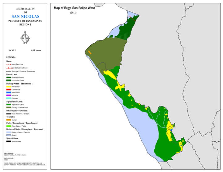
BARANGAY SAN FELIPE WEST
BRIEF SOCIO-ECONOMIC PROFILE
San Felipe was one time a big barrio inhabited by settlers coming mostly from La Union and the Ilocos provinces. These settlers were lured by the presence of gold in the sandy banks of the Agno River. These settlers made a flourishing community and named the
place San Felipe in honor of the patron saint of these religious settlers.
By virtue of the PACD’s creation of barangays in the early GO’s, San Felipe was divided into two separate barangays namely: San felipe Eastand composed of San Felipe West which covered the western portion of the barrio nearer to the Agno River with six (6)
sitios composed of Pugo, Centro, Casaratan, Carabucob, Darangindong and Moging. The barangay is bounded on the west by the Agno River; on the east by Brgy. San Felipe East; on the north by the Agno River; and on the south by Brgy.Camindoroan and Calanutian. The Agno River Provides an ample and steady Tanggal Baba Alog, Tanggal Carabucob Tanggal Pugo Carabucob, and Tanggal Pugo. The abundance of water makes farming as the principal livelihood of the people abundantly producing palay, corn and vegetables. Other sources of living are gold panning, fishing, livestock raising, overseas I and local employment as construction workers in the nearby San Roque Multi-purpose Project.
San Felipe West is one of the two host barangays of this municipality in the construction of the San Roque Dam Project and received numerous financial assistance from the National Power Corporation in terms of livelihood assistance, rural electrification project,
acquisition of two barangay vehicles, road construction, barangay road improvement, bridge construction and other infrastructure project.
Presently, Brgy. San Felipe West particularly Sitio Moging in predominantly inhabited by people coming from nearby San Manuel town. Prominent families in the barangay include the Descargar, Marzan, Dulay, Hora, Bartolome and among others.
Boundaries :
North : Brgy. SanFelipe East South : Brgys. Calanutian, Camindoroan
East : Brgy. SanFelipe East West : Mun. San
Manuel, Pang.
Distance from Poblacion
(kms.) : 7 km
Road Type : Gravel, Concrete
Seasons :
Dry – December to April
Wet – May to November
Average Annual Rainfall (mm.) 147.21 mm
Average Monthly Temperature (Celsius) 29.15°C
Status of Land classification
(has.):
|
Existing Land Uses |
Area (has.) |
|
Protection |
43.098 |
|
Production |
14.601 |
|
Grazing/Pasture |
215.209 |
|
Agricultural |
302.036 |
|
Agno |
224.395 |
|
San |
29.062 |
|
Residential |
46.762 |
|
Institutional |
0.880 |
|
Tourism |
1.028 |
|
Fisheries |
2.341 |
|
Creeks |
2.858 |
|
Road |
4.076 |
|
Total Land Area |
886.346 |
Major River : Agno
River
Soil Type : Annam
Clay Loam, Umingan Sandy Loam, Pangasinan River Sand
SOCIAL PROFILE
|
Social Profile |
|
|
Total |
1,235 |
|
Annual |
1.27 |
|
Pop. |
1 |
|
No. |
333 |
|
Ave. |
5 |
|
Sex |
117:100 |
|
Public Buildings / Facilities |
|
|
Barangay |
1 |
|
Elementary |
1 |
|
High |
|
|
Brgy. |
|
|
Brgy. |
|
|
OSCA |
|
|
Brgy. |
1 |
|
Church |
ü United |
|
Brgy. |
|
ECONOMIC SECTOR
|
Economic Sector |
|
|
Agricultural |
seedlings, |
|
Livestock/Poultry |
|
|
Existing |
|
|
Tourist |
San |
INFRASTRUCTURE AND UTILITIES
|
Infrastructure and Utilities |
|
|
Transportation |
motorcycle, |
|
Telecommunications |
sun, |
|
Postal |
|
|
Power |
PANELCO |
|
Water |
|
|
Potable |
Level |
|
Post |
|
|
Slaughterhouse |
|
|
Market |
|
BARANGAY OFFICIALS:
|
BARANGAY OFFICIALS |
||
|
Position |
Name |
|
|
Punong
Barangay |
BARTOLOME,
JOEL C. |
|
|
SBM
1 |
DOMINGO,
DAN A. |
|
|
SBM
2 |
DESCARGAR,
AMADO B. |
|
|
SBM
3 |
DESISTO,
ELVIS S. |
|
|
SBM
4 |
NITAFAN,
SYLVIA B. |
|
|
SBM
5 |
BIBAT,
FEDERICO D. JR. |
|
|
SBM
6 |
MANICLANG,
MARK JESON F. |
|
|
SBM
7 |
MARZAN,
JUANITO D. |
|
|
SK
Chairperson |
|
BARTOLATA,
RICKY BOY B. |
|
Barangay
Secretary |
MARIEFE
G. RIO |
|
|
Barangay
Treasurer |
CARIG,
JOHN JEFEYMARK P. |
|

