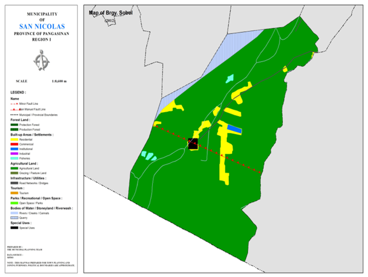
BARANGAY SOBOL
BRIEF SOCIO-ECONOMIC PROFILE
Sobol got its name from an ever-flowing spring (ubbog) that had sprouted
in the locality. The abundance supply of spring water is the source for
domestic consumption and farm irrigation. It seems that the spring was the
fountain of life which the elders called it “Sobol”. Later, people refer to the
whole place as Sobol. This legendary place called Sobol was said be located
between Calupaan and the Ambayaoan River inhabited by settlers from Tagudin,
Ilocos Sur.
Sobol was original a sitio of Barrio San Rafael located just south of
Calupaan. IT is flourishing agricultural and fishing community. Three great
floods had devastated the place that led to the exodus of its inhabitants to
higher grounds across the southern bank of the ambayoan River and to the north
of Barrio San Roque. The devastating flood in 1935 eroded a big portion of
Sobol that almost all the people evacuated. The big flood in 1976 caused by
supertyphoon “Didang” made the second wave of evacuation. And finally, the 1979
flooding overflowing Ambayaoan River made all the residents of finally decide
and transfer totally to the present location of Sobol.
Its transfer in 1935 to the proximity of Barrio San Roque had made Sobol
a sitio of San Roque. The creation of the PACD in the 60’s which intensified
the creation of barangays to foster countryside development led to the
assistance of Atty. Pedrilito Aquino, the local COMELEC Chairman at that time
and with the initiative of Anastacio Andaya. Barangay Sobol is bounded on the
north by the Ambayaoan River; on the south by Brgy. San Roque; on the east by
Brgy. Casaratan; and on the west by Brgy. Legaspi in Tayug. It is about 2 ½
kilometers away from the town proper.
Sobol had slowly recovered from its past and it is now becoming an
agricultural community with farming as its primary means of livelihood. Farm
products are palay, corn, tobacco, peanut, and vegetables like string beans,
rootcrops such as singkamas and tomato fruits. Fishing and livestock raising
are the other sources of living.
The first Teniente del Barrio of Sobol Was Severino Trinidad and
followed by Billy Villanueva. When Sobol became a Barangay, its first Barangay
Captain was Bonifacio Acosta, Sr., followed by Anastacio Andaya and Servillano
Villanueva. The present Barangay Captain is Ernesto L. Facun, who is serving
its second term.
Brgy. Sobol is a religious community with Roman Catholic as the
Dominants sect. Followed by the Seventh Day Adventist and a local sect named
Iglesia Watawat ng Lahi. Prominent families in the barangay are the Andaya,
Layco, Garcia, Castro and Bedaña among others.
The Barangay had gained a lot of important improvements and prominence.
Its river banks now are well protected due to the 1995 construction of the
three (3) kilometers protection dike in the Ambayaoan River from Sobol up to
the town proper. This protection dike served as the road linking the barangay
road constructed through the initiative of the barangay folks in 1983.
Likewise, Brgy. Sobol was the chosen site of the 11th Diocesian Jamboree for BSP and GSP of Eastern
Pangasinan in November 1996.
Boundaries :
North
:Brgys. Casaratan, San Rafael East South :Mun. Tayug, Pang.
East :Brgy. San Roque West :Brgy.
San Rafael Centro
Distance from Poblacion (kms.) : 3 km
Road Type : Gravel
Seasons :
Dry
– December to April
Wet – May to
November
Average Annual
Rainfall (mm.) 147.21 mm
Average Monthly
Temperature (Celsius) 29.15°C
Status of Land classification (has.):
|
Existing Land Uses |
Area (has.) |
|
Agricultural Land |
105.908 |
|
Quarry |
5.075 |
|
Residential |
5.930 |
|
Institutional |
0.316 |
|
Special Uses |
0.496 |
|
Fisheries |
0.531 |
|
Cannals |
0.284 |
|
Road Networks |
0.360 |
|
Total Land Area |
118.900 |
Major River :
Soil Type : Umingan Sandy Loam , San Manuel Sandy loam
SOCIAL PROFILE
|
Social Profile |
|
|
Total Pop. (NSO 2020) |
795 |
|
Annual Growth Rate |
0.62 |
|
Pop. Density |
5 |
|
No. of Households (CBMS 2020) |
181 |
|
Ave. Household Size |
4 |
|
Sex Ratio (Male/Female) |
27:25 |
|
Public Buildings / Facilities |
|
|
Barangay Hall |
1 |
|
Elementary School |
1 |
|
High School |
|
|
Rural Health Station |
|
|
Brgy. Health Center |
|
|
OSCA Building |
|
|
Brgy. Daycare Center |
1 |
|
Church |
|
|
Brgy. Cemetery |
|
|
Garbage Site Facility |
1 |
ECONOMIC SECTOR
|
Economic Sector |
|
|
Agricultural Production |
corn, palay, vegetable |
|
Livestock/Poultry Production |
|
|
Existing Industries |
|
|
Tourist Attractions |
|
INFRASTRUCTURE AND UTILITIES
|
Infrastructure and Utilities |
|
|
Transportation |
motorcycle, tricycle |
|
Telecommunications |
sun, globe, smart |
|
Postal Communication |
|
|
Power and Electrification |
PANELCO III |
|
Water Supply and Irrigation |
|
|
Potable Water Supply |
Level I |
|
Post Harvest Facilities |
|
|
Slaughterhouse |
|
|
Market |
|
BARANGAY OFFICIALS:
|
BARANGAY OFFICIALS |
||
|
Position |
Name |
|
|
Punong Barangay |
MELBA V. VISTRO |
|
|
SBM 1 |
JAYMAR FACUN |
|
|
SBM 2 |
AIZA F. BEDANA |
|
|
SBM 3 |
RENATO V. LAYCO |
|
|
SBM 4 |
MARLON B. QUINES |
|
|
SBM 5 |
JESUS J. BEDANA |
|
|
SBM 6 |
JERVIC T. VILLENA |
|
|
SBM 7 |
OLIVER C. BEDANA |
|
|
SK Chairperson |
|
ENRICO JAMES E. LAYCO |
|
Barangay Secretary |
JOCELYN GAMBOA |
|
|
Barangay Treasurer |
GEMMA BEDANA |
|

