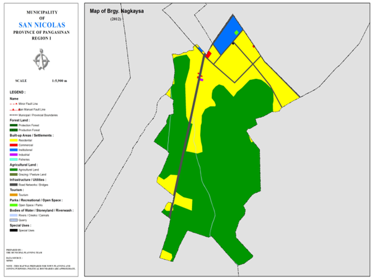
BARANGAY NAGKAYSA
BRIEF SOCIO-ECONOMIC PROFILE
It was in the mid 60’s when the barangays were the object of massive
developmental concern by the national government.The Presidential Assistance on
Community Development(PACD), was created to undertake the challenge of
development through the distribution of the much needed funds in the
countryside.
Local leaders responeded tremendously to the call of the times that
of creating barangays throughout the
country thus including poblacion or town proper. San Nicolas in particular
splitted the town proper into four barangays namely Poblacion East, Poblacion
West, Casaratan and Nagkaysa.
Nagkaysa was a part Poblacion West before 1961. It was registered later
at the municipal, provincial and national offices through the assistance of
Atty. Ildefonso Rodrigo and Atty.
Felimon Corpuz, both working with PACD in San Nicolas.
It was named “Nagkaysa” because of the concerted efforts of the barangay
residents at Aglipay St., Quezon Extension St., Patricio St., Mckinley St.,
Burgos St., and Mejia St.
Pioneering barangay officials were: Sergio Francia, Brgy. Capt. Felipe
Cancino, Alejo Corpuz, Desiderio Peria, Claudio Quinto and Enrique Bautista as
councilmen.
Boundaries :
North
:Brgy. Pob. East South :Brgy. San Roque
East :Brgy. Siblot West :Brgy. Casaratan
Distance from Poblacion (kms.) : 1st km
Road Type : Asphalt, Concrete
Seasons :
Dry
– December to April
Wet – May to
November
Average Annual
Rainfall (mm.) 147.21 mm
Average Monthly
Temperature (Celsius) 29.15°C
Status of Land classification (has.):
|
Existing Land Uses |
Area (has.) |
|
Agricultural Land |
29.278 |
|
Residential |
11.699 |
|
Commercial |
0.071 |
|
Open Space / Parks |
0.031 |
|
Institutional |
1.084 |
|
Industrial |
0.013 |
|
Special Uses |
0.007 |
|
Cannals |
0.065 |
|
Road Networks |
1.465 |
|
Total Land Area |
43.713 |
Major River :
Soil Type : Umingan Sandy Loam
SOCIAL PROFILE
|
Social Profile |
|
|
Total Pop. (NSO 2020) |
987 |
|
Annual Growth Rate |
0.28 |
|
Pop. Density |
22 |
|
No. of Households (CBMS 2020) |
261 |
|
Ave. Household Size |
5 |
|
Sex Ratio (Male/Female) |
117:100 |
|
Public Buildings / Facilities |
|
|
Barangay Hall |
1 |
|
Elementary School |
1 |
|
High School |
|
|
Brgy. Health Station |
|
|
Brgy. Health Center |
|
|
OSCA Building |
1 |
|
Brgy. Daycare Center |
|
|
Church |
|
|
Brgy. Cemetery |
|
ECONOMIC SECTOR
|
Economic Sector |
|
|
Agricultural Production |
corn, palay |
|
Livestock/Poultry Production |
|
|
Existing Industries |
|
|
Tourist Attractions |
|
INFRASTRUCTURE AND UTILITIES
|
Infrastructure and Utilities |
|
|
Transportation |
motorcycle, tricycle |
|
Telecommunications |
sun, globe, smart, PLDT |
|
Postal Communication |
|
|
Power and Electrification |
PANELCO III |
|
Water Supply and Irrigation |
|
|
Potable Water Supply |
Level III |
|
Post Harvest Facilities |
|
|
Slaughterhouse |
|
|
Market |
|
BARANGAY OFFICIALS:
|
BARANGAY OFFICIALS |
||
|
Position |
Name |
|
|
Punong Barangay |
RAMON SANCHEZ MEJIA |
|
|
SBM 1 |
MARCO
ANTONIO BALLESTEROS SOLIS |
|
|
SBM 2 |
MOISES SERQUINA LAGUA |
|
|
SBM 3 |
SERVILLANO PERIA MARCOS |
|
|
SBM 4 |
WENCY MARTINEZ RICO |
|
|
SBM 5 |
LAMIEL NICOMEDEZ GOLTIAO |
|
|
SBM 6 |
VIRGIE GEBILAGUIN OLLERO |
|
|
SBM 7 |
DARYL O. ZACARIAS |
|
|
SK Chairperson |
|
RENIEL GINES ANCHETA |
|
Barangay Secretary |
MARY LOU BEDANA |
|
|
Barangay Treasurer |
MAY FLOR BALLESTEROS |
|

