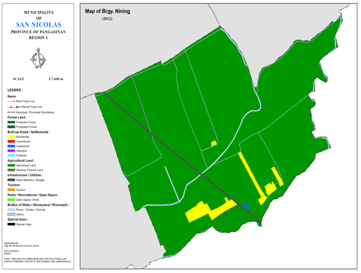
BARANGAY NINING
BRIEF SOCIO-ECONOMIC PROFILE
Barangay Nining is considered as the southern gateway of San Nicolas. It is the entry point of the municipalty from Reigion II thru San Quintin and Natividad towns. It is situated about 3 ½ kms. away south of the town proper of natividad According to old folks, Nining, was originally a sitio of Barrio San
Jose. Nining was the ‘left over’ of the barrio when part of San Jose was taken away from San Nicolas to form the municipality of Natividad in 1902. The creation of Natividad as a separate municipality led to the delineation of the boundaries between the two adjacent towns. The creek passing across the barangay became the boundary and north of the creek became Nining of Natividad.
Early settlers in Nining came from the western part of the province and form the Ilocos provinces. However, there was no existing historical records to show how Barangay Ninig got its name. Even old folks were not aware on how the word Nining became the name of the place.
The creation of barangays by the PACD in the early 60’s led to the creation of Nining as a separate barangay from Brgy. San Jose. It is bounded on the south by Municipality of Natividad; on the north by Brgy. Siblot, on the East by the Brgy . Cabitnongan and on the west by the Brgy . San Jose. The place is a flourishing agricultural community being endowed by nature with rich and fertile soil, good community being endowed by nature with rich farm produce like palay, corn , tobacco, mongo and vegetables. Livestock raising is another source of income.
Prominent families in the barangay are the Ubera, Arellaga, Apigo and Aquino among others.
Boundaries :
North :Brgy. Siblot South :Brgy. San Jose
East :Brgy. Cacabugaoan West :Mun. Natividad, Pang.
Distance from Poblacion (kms.) : 3.5 km
Road Type : Gravel, Concrete
Seasons :
Dry– December to April
Wet – May to November
Average Annual Rainfall (mm.) 147.21 mm
Average Monthly Temperature (Celsius) 29.15°C
Status of Land classification (has.):
|
Existing Land Uses |
Area (has.) |
|
Agricultural Land |
129.807 |
|
Institutional |
0.077 |
|
Cannals |
0.414 |
|
Creeks |
1.545 |
|
Road Networks |
1.223 |
|
Total Land Area |
133.067 |
Major River :
Soil Type Umingan Sandy Loam
SOCIAL PROFILE
|
Social Profile |
|
|
Total Pop. (NSO 2020) |
515 |
|
Annual Growth Rate |
3.99 |
|
Pop. Density |
3 |
|
No. of Households (CBMS 2020) |
133 |
|
Ave. Household Size |
5 |
|
Sex Ratio (Male/Female) |
49:50 |
|
Public Buildings / Facilities |
|
|
Barangay Hall |
1 |
|
Elementary School |
1 |
|
High School |
|
|
Brgy. Health Station |
|
|
Brgy. Health Center |
|
|
OSCA Building |
|
|
Brgy. Daycare Center |
1 |
|
Church |
|
|
Brgy. Cemetery |
|
ECONOMIC SECTOR
|
Economic Sector |
|
|
Agricultural Production |
corn, palay, vegetable |
|
Livestock/Poultry Production |
|
|
Existing Industries |
|
|
Tourist Attractions |
|
INFRASTRUCTURE AND UTILITIES
|
Infrastructure and Utilities |
|
|
Transportation |
motorcycle, tricycle |
|
Telecommunications |
sun, globe, smart |
|
Postal Communication |
|
|
Power and Electrification |
PANELCO III |
|
Water Supply and Irrigation |
|
|
Potable Water Supply |
Level I, Level III |
|
Post Harvest Facilities |
|
|
Slaughterhouse |
|
|
Market |
|
BARANGAY OFFICIALS:
|
BARANGAY OFFICIALS |
||
|
Position |
Name |
|
|
Punong Barangay |
MICHAEL VIDAL PAGAL |
|
|
SBM 1 |
JERRY SANTOS UBERA |
|
|
SBM 2 |
ARTHUR AUINO CAJIO, JR |
|
|
SBM 3 |
MELANIE MARQUEZ BIBAT |
|
|
SBM 4 |
MARISSA PRADO LINING |
|
|
SBM 5 |
JHERRY CABEZA ABORDO |
|
|
SBM 6 |
FELIROSE MUNOZ SILAPAN |
|
|
SBM 7 |
TESSIE UBERA DIAZ |
|
|
SK Chairperson |
|
LADY JANINE DIAZ CAPINDIAN |
|
Barangay Secretary |
VANESSA S. CAJIO |
|
|
Barangay Treasurer |
LORETA A. ARELLAGA |
|

