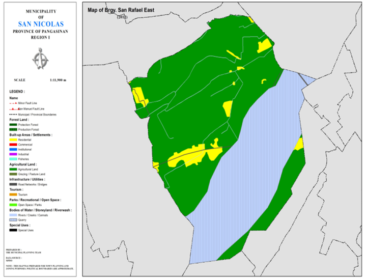
BARANGAY SAN RAFAEL EAST
BRIEF SOCIO-ECONOMIC PROFILE
Barangay San Rafael East was
formerly a part of Barrio San Rafael prior to its division into two (2)
barangays. In 1972, then President Ferdinand E. Marcos issued a Presidential
Decree that led to the further division of Barrio San Rafael into Three (3)
barangays namely: San Rafael East, San Rafael West; and San Rafael Centro. The
(3) barangays is now commonly known as San Rafael District.
Barangay San Rafael East
comprises the Sitio Marintec, the center of the barangay and its name derived
from the sound of a “Mangarmang” bird; Sitio Parbo derived is name from the
word “Parnuay” which means to pruduce; and
Sitio Panfila, formely Sitio Malasin, was named in honor of Mrs. Panfila
Serquiña Descargar, who was then the owner of huge residential and farm lands.
The inhabitants of Ilococs were the early settlers arrived in the area to seek
better economic opportunities. Farming is predominant means of laivelihood
prior to the arrival of the settlers the area was a grassland but fertile
enough to produce a good variety of agricultural products.
Barangay San Rafael East is
also considered as among the top agricultural products producer barangay in the
municipality of San Nicolas, Pangasinan raging from rice and corn to variety of
vegetables.
Today, Barangay San Rafael East is flourishing by its abundance farmlands. Inhabitants living there at are predominantly farmers with a common vision that their children will become very fruitful in farming through the use of modern implements and advance trend oof farming coupled with the implementation of the Country Energization Program of the National Government under Hon. Conrado M. Estrella III, NEA Administrator
Boundaries :
North : Brgys. Cabuloan, Lungao South : Brgy. Sobol
East : Brgy. Casaratan West :
Brgy. San Rafael Centro
Distance from Poblacion (kms.) : 2 km
Road Type : Concrete
Seasons :
Dry – December to April
Wet – May to November
Average Annual Rainfall (mm.) 147.21 mm
Average Monthly Temperature (Celsius) 29.15°C
Status of Land classification (has.):
|
Existing Land Uses |
Area (has.) |
|
Agricultural
Land |
156.524 |
|
Quarry |
98.132 |
|
Residential |
11.664 |
|
Cannals |
0.563 |
|
Road
Networks |
0.962 |
|
Total Land Area |
267.845 |
Major River : Ambayoan River
Soil Type : Umingan
Sandy Loam
SOCIAL PROFILE
|
Social Profile |
|
|
Total
Pop. (NSO 2020) |
988 |
|
Annual
Growth Rate |
-1.67 |
|
Pop.
Density |
3 |
|
No.
of Households (CBMS 2020) |
254 |
|
Ave.
Household Size |
4 |
|
Sex
Ratio (Male/Female) |
51:50 |
|
Public Buildings / Facilities |
|
|
Barangay
Hall |
1 |
|
Elementary
School |
|
|
High
School |
|
|
Brgy.
Health Station |
|
|
Brgy.
Health Center |
|
|
OSCA
Building |
|
|
Brgy.
Daycare Center |
1 |
|
Church |
üUnited
Methodist üUECDFI |
|
Brgy.
Cemetery |
|
ECONOMIC SECTOR
|
Economic Sector |
|
|
Agricultural
Production |
corn,
palay, vegetable |
|
Livestock/Poultry
Production |
|
|
Existing
Industries |
|
|
Tourist
Attractions |
|
INFRASTRUCTURE AND UTILITIES
|
Infrastructure and Utilities |
|
|
Transportation |
motorcycle,
tricycle |
|
Telecommunications |
sun,
globe, smart |
|
Postal
Communication |
|
|
Power
and Electrification |
PANELCO
III |
|
Water
Supply and Irrigation |
|
|
Potable
Water Supply |
Level
I |
|
Post
Harvest Facilities |
|
|
Slaughterhouse |
|
|
Market |
|
BARANGAY OFFICIALS:
|
BARANGAY OFFICIALS |
||
|
Position |
Name |
|
|
Punong
Barangay |
RODILLAS,
MELINDA G. |
|
|
SBM
1 |
TAMAYO,
JOJO R. |
|
|
SBM
2 |
LAYCO,
ELMA F. |
|
|
SBM
3 |
CAYABAN,
OLIVER R. |
|
|
SBM
4 |
CAYABAN,
RUDY S. JR. |
|
|
SBM
5 |
CLAVERIA,
NELSON D. |
|
|
SBM
6 |
LEAL,
SACRIS C. |
|
|
SBM
7 |
TUCAY,
ARSENIOM F. |
|
|
SK
Chairperson |
|
MANANSALA,
GIAN JETHRO U. |
|
Barangay
Secretary |
BARRIENTOS,
ANA MARIA |
|
|
Barangay
Treasurer |
RUDIO,
HELARY |
|

