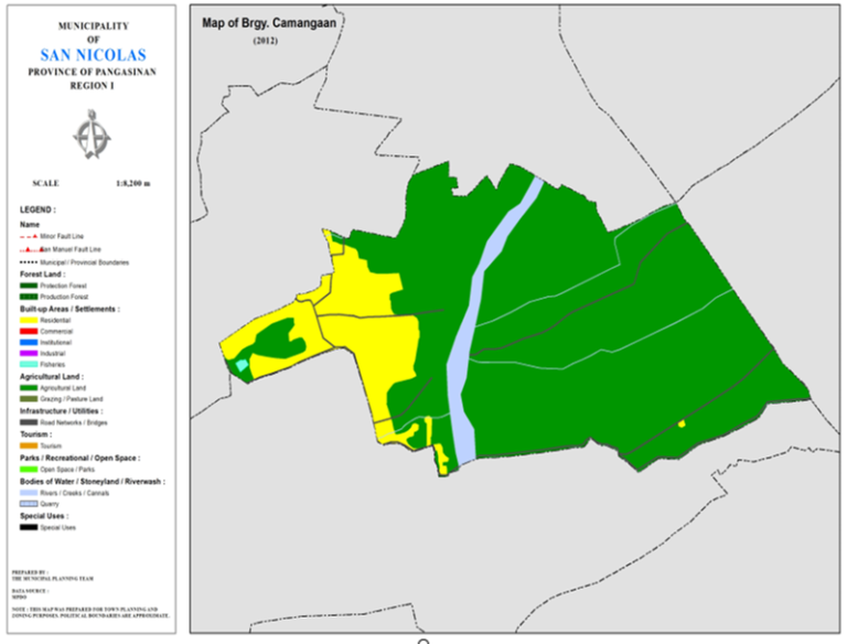
BARANGAY CAMANGAAN
BRIEF SOCIO-ECONOMIC PROFILE
Barangay Camanggaan was formerly a sitio of Barangay Sto. Tomas before the 70s. Early settlers in the place came from Dingras, Sarrat and Piddig, Ilocos Norte in the later part of the 19th century. These adventurous Ilokanos were led by Bolinao, Evangelista, Paraguas, Luzano, Mariano and other families who established their homes with farming as the primary source of their livelihood.
The place was blessed with thick forest trees and other fruit-bearing trees like mangoes or mangga in the local dialect. Every backyard has mango fruit bearing trees. People from adjacent barangays called the place as “Camanggaan” because of the abundance of mango trees in the locality.
The first members of the barangay council included the following: Cresencia Bibat, Brgy. Captain Celedonio Balno, Bonifacio Vicente, Isabelo Pascua, Armenio Pascua, Tomas Valdez and Avelino Ubatto, councilmen.
Other source of income are livestock raising, gold panning, and overseas employment. A tourist spot is the San Sebastian Dam in the Sabangan River, which attracts picnickers.
Boundaries :
North : Brgy. Malilion South : Brgy. Cabuloan
East : Brgy. Lungao West : Brgy. Sto. Tomas
Distance from Poblacion (kms.) : 5 km
Road Type : Gravel, Concrete
Seasons :
Dry – December to April
Wet – May to November
Average Annual Rainfall (mm.) 147.21 mm
Average Monthly Temperature (Celsius) 29.15°C
Status of Land classification (has.):
Existing Land Uses | Area (has.) |
Agricultural Land | 72.071 |
Sabangan River | 3.632 |
Residential | 11.895 |
Fisheries | 0.075 |
Cannals | 0.208 |
Road Networks | 1.342 |
Total Land Area | 89.224 |
Major River : Sabangan River
Soil Type : Umingan Sandy Loam,
SOCIAL PROFILE
Social Profile | |
Total Pop. (NSO 2020) | 762 |
Annual Growth Rate | -1.07 |
Pop. Density | 7 |
No. of Households (CBMS 2020) | 185 |
Ave. Household Size | 5 |
Sex Ratio (Male/Female) | 53:50 |
Public Buildings / Facilities | |
Barangay Hall | 1 |
Elementary School | |
High School | |
Brgy. Health Station | |
Brgy. Health Center | |
OSCA Building | |
Brgy. Daycare Center | 1 |
Church | ü Iglesia ni Cristo |
Brgy. Cemetery | |
ECONOMIC SECTOR
Economic Sector | |
Agricultural Production | corn, palay |
Livestock/Poultry Production |
|
Existing Industries |
|
Tourist Attractions |
|
INFRASTRUCTURE AND UTILITIES
Infrastructure and Utilities | |
Transportation | motorcycle, tricycle |
Telecommunications | sun, globe, smart |
Postal Communication |
|
Power and Electrification | PANELCO III |
Water Supply and Irrigation |
|
Potable Water Supply | Level I |
Post Harvest Facilities |
|
Slaughterhouse |
|
Market |
|
BARANGAY OFFICIALS:
BARANGAY OFFICIALS | ||
Position | Name | |
Punong Barangay | HERMINIGILDO DOTIMAS DOTON | |
SBM 1 | TEODOLO BIBAT MARIANO | |
SBM 2 | JOCELYN DOMINGO CABE | |
SBM 3 | ERNESTO CAYBYAB CORPUZ | |
SBM 4 | MARLON SERMONIA SIKAT | |
SBM 5 | NICOLAS DOTON TOLENTINO | |
SBM 6 | CERENIO DOTIMAS DOTON | |
SBM 7 | FERDINAN SIMON BIBAT | |
SK Chairperson |
| ANGIO MARIANO BIBAT |
Barangay Secretary | JHOY A. VIRAY | |
Barangay Treasurer | REVIE A CABRITO | |

