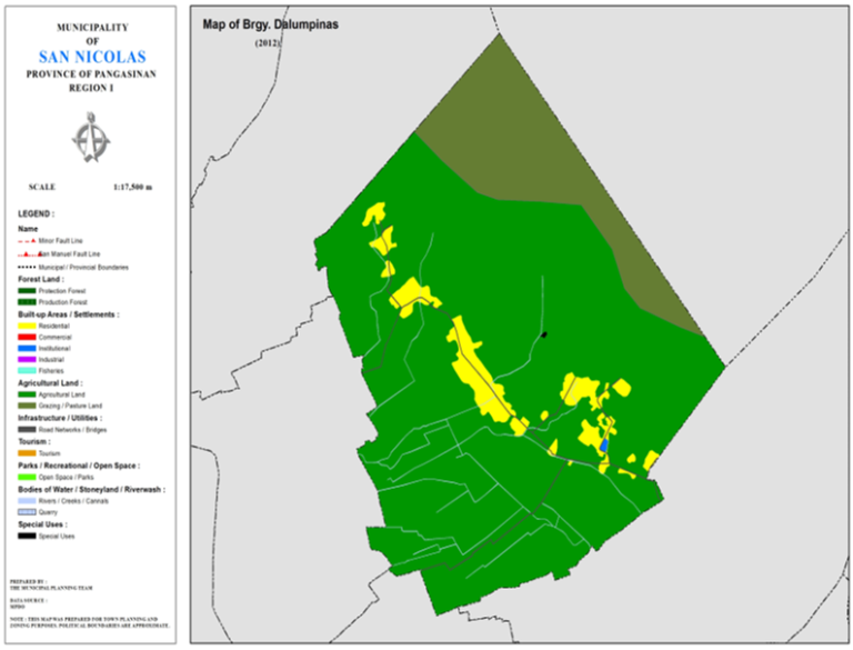
BARANGAY DALUMPINAS
BRIEF SOCIO-ECONOMIC PROFILE
In 1916, one of the early settlers of the land, identified as Dionisio Ortiguero, named the area as Dalumpinas. The named was derived from a big, flat rock commonly called by early settlers as “Dinalumpinas a Bato” which was found at the mouth of the Dagdaguen Creek. The first Teniente del Barrio was Vicente Fernandez and the second was Eliseo Martinez.
Before World War II brokeout, Dalumpinas was a sitio of Barrio of San Antonio. However, because of its increasing annual population rate, the late Eliseo Martinez, Personally initiated the passing of a resolution by the Municipal Council in 1962, Sition Dalumpinas was created and converted into a barrio.
In 1938, a primary class was established under Mr. Manuel Pacla and later on, additional two (2) other classes was opened under Mr. Manuel Rodrigo, Sr. in 1952, a complete elementary school was established and intermediate class was held in the Gabaldon building with Mr. Eduardo Navarro and Julian P. Martinez as the first intermediate school teacher and school principal, respectively.
Several of its inhabitants are currently employed as OCW’s in the middle east, Europe, Hong Kong and Asia countries and actively extending assistance in barangay projects.
Barangay Dalumpinas is one of the biggest barangay among the thirty three (33) barangay of San Nicolas. It is situated at the foot of the Caraballo Mountain and more of less six (6) kilometers away from the town proper. It is among the eighteen (18) barangays located in the east by Brgy. San Isidro, and in the north by the Caraballo Mountain. It is divided into four (4) purok, namely: Purok Minong (Eastern Dalumpinas) with a total population of 497 and 102 households; Purok Santos (Central Dalumpinas) with a total population of 201 and 45 households; Purok Pablo (Centro) with a toatal population of 193 and 47 households; Purok Prudencio with a total population of 246 and 42 households.
Barangay has an estimated total land area of more or less 250 hectares of with 200 hectares is considered as agricultural land; 20 hectares is classified as residential lands; and the remaining 30 hectares as rolling hills planted with varieties of trees and fruit bearing trees like mangoes, kasuy and others. The principal farm has an approximate annual farm
Boundaries :
North : Brgy. Bensican South : Brgy. Salingcob
East : Brgy. Fianza West : Brgy. San Isidro
Distance from Poblacion (kms.) : 7 km
Road Type : Gravel, Concrete
Seasons :
Dry – December to April
Wet – May to November
Average Annual Rainfall (mm.) 147.21 mm
Average Monthly Temperature (Celsius) 29.15°C
Status of Land classification (has.):
Existing Land Uses | Area (has.) |
Grazing/Pasture Land | 81.297 |
Agricultural Land | 401.867 |
Residential | 24.710 |
Institutional | 0.254 |
Special Uses | 0.071 |
Cannals | 1.010 |
Road Networks | 1.760 |
Total Land Area | 510.970 |
Major River :
Soil Type : Umingan Sandy Loam, Annam Clay Loam
SOCIAL PROFILE
Social Profile | |
Total Pop. (NSO 2020) | 1,687 |
Annual Growth Rate | 0.87 |
Pop. Density | 3 |
No. of Households (CBMS 2020) | 423 |
Ave. Household Size | 4 |
Sex Ratio (Male/Female) | 21:20 |
Public Buildings / Facilities | |
Barangay Hall | 1 |
Elementary School | 1 |
High School | 1 |
Brgy. Health Station | |
Brgy. Health Center | |
OSCA Building | 1 |
Brgy. Daycare Center | 1 |
Church | ü UCCP ü UECDFI |
Brgy. Cemetery | 1 |
ECONOMIC SECTOR
Economic Sector | |
Agricultural Production | corn, palay, vegetable |
Livestock/Poultry Production |
|
Existing Industries |
|
Tourist Attractions |
|
INFRASTRUCTURE AND UTILITIES
Infrastructure and Utilities | |
Transportation | motorcycle, tricycle, jeep |
Telecommunications | sun, globe, smart |
Postal Communication |
|
Power and Electrification | PANELCO III |
Water Supply and Irrigation |
|
Potable Water Supply | Level I, Level II, Level III |
Post Harvest Facilities |
|
Slaughterhouse |
|
Market |
|
BARANGAY OFFICIALS:
BARANGAY OFFICIALS | ||
Position | Name | |
Punong Barangay | JUANITO SUYAT MENDOZA | |
SBM 1 | ENRICO LIGMAYO HORA | |
SBM 2 | MYRA VICTORINA GULLA | |
SBM 3 | MAGDALENA MARTINEZ FABRO | |
SBM 4 | LEONCIO GULLA MARTINEZ | |
SBM 5 | JOHNICO VALLEJOS SUYAT | |
SBM 6 | ARIEL SUYAT LOZANO | |
SBM 7 | JOSENIOBATRINA CACAYAN | |
SK Chairperson |
| SCHOFIELD MARTINEZ DOTON |
Barangay Secretary | ANGELICA HALOJANAN | |
Barangay Treasurer | MARICEL O. DOMINGO | |

