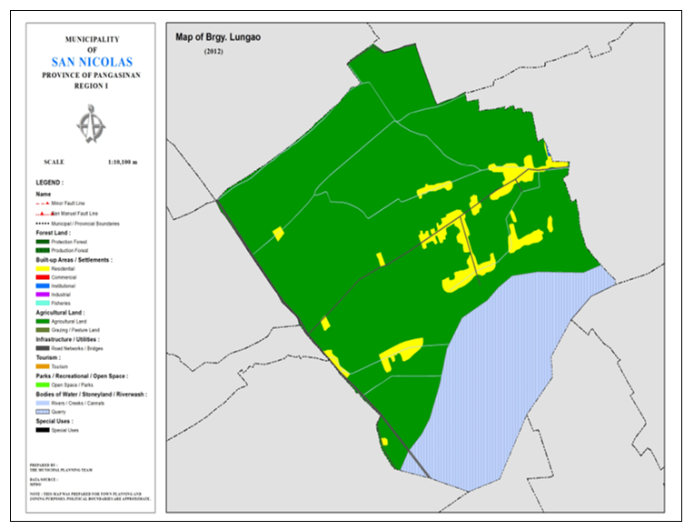
BARANGAY LUNGAO
BRIEF SOCIO-ECONOMIC PROFILE
Lungao was formerly a sitio of barrio San Antonio along with Salingcob and Dalumpinas. Due to the increase in population and the PACD creation of barangays in the 60’s, it was converted as a separate barangay. Lungao is bounded on the north by Brgy. Dalumpinas, on the south by Ambayaoan River.Salingcob; and on the west by Brgy.Camanggaan. It has an approximate land area of 900 hectares.
It remained a mystery on how the barnagay acquired the name Lungao. No historical data could be found. Even the elders in the barangay has no story to tell on how it derived its name.
Before the 70’s, Lungao was already a progressive and a thickly populated community. It shared the same San Antonio Elementary School with Salingcob. The San Antonio Barangay High School in the same campus was the first public school established in the municipality and founded by the late Mr. Edilberto Tamondong. Lungao became a virtual model farm, demo farm and experimental farm rolled in to one due to the pioneering agricultural ventures of Mr. Edilberto Tamondong, Don Gaudencio Marciano and Mr. Andres Lopez. They made Lungao a top vegetable producer and made San Nicolas rose from rural obscurity to regional prominence by being dubbed as the “Vegetable Basket of Eastern Pangasinan.”
In 1976, super typhoon “Didang” devastated San Nicolas by giving the biggest flood ever recorded in the history of our town. The Ambayaoan River overflowed and totally washed out the residential area of San Antonio. The entire school campus was totally washed away so were the dwellings of Lungao and Salingcob and the people were forced to evacuate. The community was in total disarray. Some residents fled to higher grounds for safety in Brgy. Salingcob “Little Baguio”. Others who could not simply leave their farms had stayed behind in the place now called “Nagpanawan”- Presently a sitio of Salingcob. White most of Lungao residents simply settled inward away from the Ambayaoan River, Brgy. Capt. Pedro Sulio was instrumental in the construction of a new roadline from the Provincial road going to the barnagay as all of the barangay roads were washed out by the flood. This road is now usually called Lungao Road which interconnects the barangay to the town proper and a major route to Barangay Salingcob and Dalumpinas.
Lungao has now recovered from the 1976 flood and greatly improved and progressed as a barangay. Yet, it is now only a few meters away from the unprotected riverbank that every rainy season brings back the memories of the great 1976 flood to the people.
With steady supply of water from Ambayaoan, and blessed with rich fertile and sturdy industrious people, Lungao is still a booming agricultural community. Farming is the primary source of income with palay, corn and vegetable as the main farm produce. Livestock raising and overseas employment as secondary source of income.
Boundaries :
North : Brgy. Dalumpinas South : Brgy. San Rafael East
East : Brgy. Salingcob West : Brgy. Camangaan
Distance from Poblacion (kms.) : 2.5 km
Road Type : Asphalt, Concrete
Seasons :
Dry – December to April
Wet – May to November
Average Annual Rainfall (mm.) 147.21 mm
Average Monthly Temperature (Celsius) 29.15°C
Status of Land classification (has.):
Existing Land Uses | Area (has.) |
Agricultural Land | 151.906 |
Quarry | 46.219 |
Residential | 9.713 |
Institutional | 0.030 |
Cannals | 0.488 |
Road Networks | 1.818 |
Total Land Area | 210.174 |
Major River : Ambayoan River
Soil Type : Umingan Sandy Loam
SOCIAL PROFILE
Social Profile | |
Total Pop. (NSO 2020) | 795 |
Annual Growth Rate | -2.23 |
Pop. Density | 3 |
No. of Households (CBMS 2020) | 196 |
Ave. Household Size | 4 |
Sex Ratio (Male/Female) | 99:100 |
Public Buildings / Facilities | |
Barangay Hall | 1 |
Elementary School | 1 |
High School | |
Brgy. Health Station | |
Brgy. Health Center | 1 |
OSCA Building | |
Brgy. Daycare Center | 1 |
Church | |
Brgy. Cemetery | |
ECONOMIC SECTOR
Economic Sector | |
Agricultural Production | corn, palay, vegetable |
Livestock/Poultry Production |
|
Existing Industries |
|
Tourist Attractions |
|
INFRASTRUCTURE AND UTILITIES
Infrastructure and Utilities | |
Transportation | motorcycle, tricycle, jeep |
Telecommunications | sun, globe, smart |
Postal Communication |
|
Power and Electrification | PANELCO III |
Water Supply and Irrigation |
|
Potable Water Supply | Level II |
Post Harvest Facilities |
|
Slaughterhouse |
|
Market |
|
BARANGAY OFFICIALS:
BARANGAY OFFICIALS | ||
Position | Name | |
Punong Barangay | RANDY LAZO ROSENDO | |
SBM 1 | MARLON CAMILOZA SERIOSA | |
SBM 2 | JERRY FABIONAR JAVINAR | |
SBM 3 | HILDA CASER VALLEJOS | |
SBM 4 | MYLA ESTABILLO BADUA | |
SBM 5 | ENRY CATUIZA CASER | |
SBM 6 | QUIRICO SULIO FABIONAR | |
SBM 7 | DIGNA ARQUERO PARAYPAYAN | |
SK Chairperson |
| FLORENCE NICOLE CATUIZA CASER |
Barangay Secretary | MARIENELLA P. ARQUERO | |
Barangay Treasurer | YOLANDA B. FABIONAR | |

