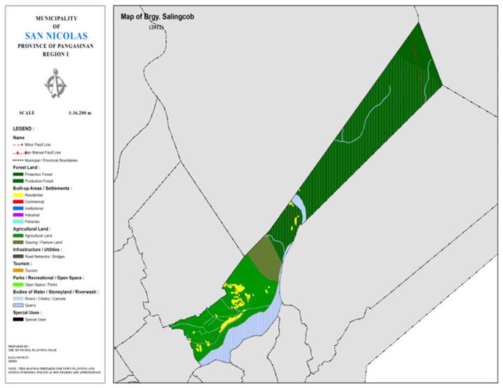
BARANGAY SALINGCOB
BRIEF SOCIO-ECONOMIC PROFILE
Historical data show that a certain barrio of the town called San Antonio composed of three sitios namely Simmalingcob, Lungao and Dalumpinas. Due to the increase in population, these three sitios were converted in three separate barangays. Each barnagay was then under a leader called Barrio Lieutenant. At that time, the late Hon. Diosdado Macapagal was the president of the Republic of the Philippines, Hon. Conrado
Estrella was the governor of Pangasinan and the late Hon. Pacifico Ylarde was the municipal mayor. Thus the birth of Barangay Salingcob.
Years Passed and Barangay Salingcob slowly became a progressive barangay. Feeder roads, and farm-to-market roads were constructed to facilitate the transport of their products to the market. But in the year 1976, as super typhoon named “Didang” devastated Northern and Central Luzon, San Nicolas suffered from considered as biggest floods ever recorded in the history of this town. The Ambayaoan River overflowed its banks and almost totally washed out the whole barangay of Salingcob, the dwellings, the community elementary school and barangay high school. The populace was then forced to evacuated and settle to higher place called Simmalingcob, now Salingcob.
At present, Barnagay Salingcob is situated at the foot of the Caraballo Mountains, about seven kilometer away from the town proper it is also known as “little Baguio” of San Nicolas because of the houses were built at the foot and slope of small hills and with winding roads going up and town. The barangay has an area of 200 hectares more or less, with a population of 750. Most of the people are engaged in farming and planting and has enough water supply throughout the year for its and second copings of palay thus making the populace self-employed and self-sufficient.
Barangay Salingcob is present under the administration of barangay Captain Maciste R. Ortiguero and other barangay officials namely: Marcos F. Batin, Jr., Cesario C. Marquez, Herminigildo J. Batin, Pelagio S. Rubator, jr., Victor O. Cacayan, Rudy V. Yranon, Zaldy B. Fabro as markers of the brgy. Council, Barangay Secretary Felipe B. Batin, Sr., and Barangay Treasurer Roberto Y. Catuiza.
Boundaries :
North : Brgy. Fianza, Dalumpinas South : Brgy. Camangaan
East : Brgy. Sta. Maria East West : Brgy. Lungao
Distance from Poblacion (kms.) : 5.5 km
Road Type : Earth Trail, Gravel, Concrete
Seasons :
Dry – December to April
Wet – May to November
Average Annual Rainfall (mm.) 147.21 mm
Average Monthly Temperature (Celsius) 29.15°C
Status of Land classification(has.):
|
Existing Land Uses |
Area (has.) |
|
Protection |
46.875 |
|
Production |
380.852 |
|
Grazing/Pasture |
41.940 |
|
Agricultural |
175.228 |
|
Ambayoan |
8.725 |
|
Quarry |
71.370 |
|
Residential |
16.281 |
|
Institutional |
0.163 |
|
Cannals |
0.533 |
|
Creeks |
2.290 |
|
Road |
1.153 |
|
Total Land Area |
745.412 |
Major River : Abayoan River
Soil Type : Annam Clay Loam, Umingan Sandy Loam,
SOCIAL PROFILE
|
Social Profile |
|
|
Total |
974 |
|
Annual |
3.98 |
|
Pop. |
1 |
|
No. |
222 |
|
Ave. |
4 |
|
Sex |
53:50 |
ECONOMIC SECTOR
|
Economic Sector |
|
|
Agricultural |
vegetable |
|
Livestock/Poultry |
|
|
Existing |
|
|
Tourist |
|
INFRASTRUCTURE AND UTILITIES
|
Infrastructure and Utilities |
|
|
Transportation |
motorcycle, |
|
Telecommunications |
sun, |
|
Postal |
|
|
Power |
PANELCO |
|
Water |
|
|
Potable |
Level |
|
Post |
|
|
Slaughterhouse |
|
|
Market |
|
BARANGAY OFFICIALS:
|
BARANGAY OFFICIALS |
||
|
Position |
Name |
|
|
Punong |
NOEL |
|
|
SBM |
RAUL |
|
|
SBM |
OLIVER |
|
|
SBM |
DAVID |
|
|
SBM |
MARWIN |
|
|
SBM |
RONALDD |
|
|
SBM |
MAMERTO |
|
|
SBM |
FERNANDO |
|
|
SK |
|
GODWIN |
|
Barangay |
ROMAN |
|
|
Barangay |
LORETO |
|

