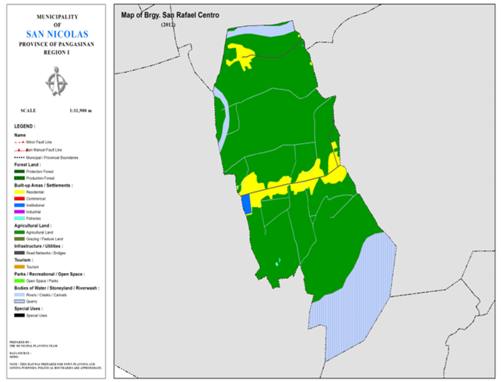
BARANGAY SAN RAFAEL CENTRO
BRIEF SOCIO-ECONOMIC PROFILE
Barrio San Rafael is a
flourishing place of the municipality. It is three (3) kilometers west of the
town proper and it is situated along the northern side of the Ambayaoan River.
The Barrio was composed of many sitios, namely: Sitio Calupaan, Sitio Centro,
Sitio Casapangan; Sition Parbo, Sitio Marintec and Sitio Malasin. San Rafael
was only one barrio before with its name derived from the patron saint, “San
Rafael.” The adventurous people of the Ilocos province were the original
settlers who arrived to seek greener pastures and better opportunities.
With the creation of the PACD
in the 60’s to foster countryside development, Barrio of San Rafael was divided
into three separate barangays. Sitio Calupaan became San Rafael West, Sitio
Parbo, Marintec and Malasin became San Rafael East and Sitio Centro and
Casapangan became San Rafael Centro. These Three barangays is now known as San
Rafael District with San Rafael Centro as the center of the district. It is
where the elementary school and the high school of the three barangays are
found. The original lot of the high school was donated by the late Don Macario
Paraguas, who was from Sitio Calupaan, While the elementary school lot was
donated by Don Guillermo Bedaña of San Rafael Centro.
Barangay San Rafael Centro is
still composed of Sitio Centro and Casapangan. It is bounded on the east by San
Rafael East; on the west by San Rafael West; on the north by the Sabangan
River; and on the south by the Ambayaoan River. It is basically a flourishing
agricultural community with farm produce ranges from palay, corn and cassava to
variety of fruits and vegetable like sineguelas, calamansi and mongo. The Rural
Electrification Program of the government thru PANELCO III had brought progress
in the community and the standard of living increased. Other sources of income
like welding shops and piggeries had proliferated.
The barangay is predominantly
of Roman Catholic although other sects existed. Also considered by the
inhabitants as part of their barangay history was the birth of the first birth
known living triplets in the history of San Nicolas. Their parents Mr. ELpidio
M. Soria and Mrs. Demetria named their triplet sons, Sherwin, Erwin and Darwin.
The triplet are now Twenty-three (23) years old and all professionals.
Prominent families of San Rafael Centro are the Rodillas, Dotimas, Bibat, Dela Cruz, and Doton among others. Prominent barangay leaders of the municipality as municipal councilors includes Don Policarpio H. Bibat, Don Silvestre Dotimas, Don Claudio Dotimas and Don Roberto Rodillas. Incumbent councilor Genaro “Boyet” R. Paraguas, jr. is also a native of this place and presently the district councilor of the San Rafael Distric Boundaries :
North : Brgy. Cabuloan South : Brgy. Sobol
East : Brgy. San Rafael East West : Brgy. San
Rafael West
Distance from Poblacion
(kms.) : 2.5 km
Road Type : Concrete
Seasons :
Dry – December to April
Wet – May to November
Average Annual Rainfall (mm.) 147.21 mm
Average Monthly Temperature (Celsius) 29.15°C
Status of Land classification (has.):
|
Existing Land Uses |
Area (has.) |
|
Agricultural
Land |
124.497 |
|
Sabangan
River |
4.453 |
|
Quarry |
27.869 |
|
Residential |
11.300 |
|
Institutional |
0.742 |
|
Fisheries |
0.044 |
|
Cannals |
0.456 |
|
Road
Networks |
0.755 |
|
Total Land Area |
170.116 |
Major River : Ambayoan River, Sabangan River
Soil Type : Umingan
Sandy Loam
SOCIAL PROFILE
|
Social Profile |
|
|
Total
Pop. (NSO 2020) |
900 |
|
Annual
Growth Rate |
0.00 |
|
Pop.
Density |
4 |
|
No.
of Households (CBMS 2020) |
233 |
|
Ave.
Household Size |
4 |
|
Sex
Ratio (Male/Female) |
103:100 |
|
Public Buildings / Facilities |
|
|
Barangay
Hall |
1 |
|
Elementary
School |
1 |
|
High
School |
1 |
|
Brgy.
Health Station |
|
|
Brgy.
Health Center |
1 |
|
OSCA
Building |
|
|
Brgy.
Daycare Center |
1 |
|
Church |
|
|
Brgy.
Cemetery |
|
ECONOMIC SECTOR
|
Economic Sector |
|
|
Agricultural
Production |
corn,
palay, vegetable |
|
Livestock/Poultry
Production |
|
|
Existing
Industries |
|
|
Tourist
Attractions |
|
INFRASTRUCTURE AND UTILITIES
|
Infrastructure and Utilities |
|
|
Transportation |
motorcycle,
tricycle |
|
Telecommunications |
sun,
globe, smart |
|
Postal
Communication |
|
|
Power
and Electrification |
PANELCO
III |
|
Water
Supply and Irrigation |
|
|
Potable
Water Supply |
Level
I |
|
Post
Harvest Facilities |
|
|
Slaughterhouse |
|
|
Market |
|
BARANGAY OFFICIALS:
|
BARANGAY OFFICIALS |
||
|
Position |
Name |
|
|
Punong
Barangay |
BIBAT,
FILIPINO T. |
|
|
SBM
1 |
VENTURA,
LORETO T. |
|
|
SBM
2 |
ITLIONG,
JOMELYN R. |
|
|
SBM
3 |
BLAS,
ELVIRA M. |
|
|
SBM
4 |
DOTON,
ROMUALDO T. |
|
|
SBM
5 |
RODILLAS,
LETICIA I. |
|
|
SBM
6 |
JAMES,
JAMES C. |
|
|
SBM
7 |
DOCTOR,
JED C. |
|
|
SK
Chairperson |
|
ACHIVARA,
JOHN ALFRED R. |
|
Barangay
Secretary |
ISIT,
AUREA MONA |
|
|
Barangay
Treasurer |
FANOGA
ANTONINO |
|

