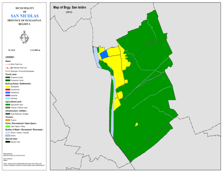
BARANGAY SAN ISIDRO
BRIEF SOCIO-ECONOMIC PROFILE
San Isidro was a premier
barangay or barrio before the outbreak of the Second World War encompassing
Malilion, Bensican and Salpad with a total land area of 543 hectares.
However, with the creation of
PACD in the 60’s, other barangays were organized to accelerate the impending
development in the counrtryside. Reduced to merely 85-90 hectares in area, San
Isidro has only 3 sitios now, Nagcoralan, Sta. Crusan and San Juan with a
population of 728 based in the latest census.
Ast its name signifies, this
barangay is named after San Isidro, the patron saint of farmers and
agriculture. Up to this time the belief in the powers of intercessory prayers
of their patron saint working wonders of the welfare of the people is very much
alive.
The development of the barangay takes us back to the pioneers from Ilocos in 1920 who came to settle in this barangay like the Laureta, Serquiña, Martinez and Lucas clans.
Boundaries :
North : Brgy. Bensican South : Brgy. Camangaan
East : Brgy. Dalumpinas West : Brgy. Malilion
Distance from Poblacion (kms.) : 3.5 km
Road Type : Gravel, Concrete
Seasons :
Dry – December to April
Wet – May to November
Average Annual Rainfall (mm.) 147.21 mm
Average Monthly Temperature (Celsius) 29.15°C
Status of Land classification
(has.):
|
Existing Land Uses |
Area (has.) |
|
Agricultural
Land |
158.492 |
|
Sabangan
River |
3.250 |
|
Residential |
19.920 |
|
Institutional |
1.211 |
|
Fisheries |
0.057 |
|
Cannals |
0.340 |
|
Creeks |
0.036 |
|
Road
Networks |
2.207 |
|
Total Land Area |
1,071.860 |
Major River : Sabangan
River
Soil Type : Umingan
Sandy Loam
SOCIAL PROFILE
|
Social Profile |
|
|
Total
Pop. (NSO 2020) |
899 |
|
Annual
Growth Rate |
-0.55 |
|
Pop.
Density |
4 |
|
No.
of Households (CBMS 2020) |
207 |
|
Ave.
Household Size |
4 |
|
Sex
Ratio (Male/Female) |
51:50 |
|
Public Buildings / Facilities |
|
|
Barangay
Hall |
1 |
|
Elementary
School |
1 |
|
High
School |
1 |
|
Brgy.
Health Station |
|
|
Brgy.
Health Center |
|
|
OSCA
Building |
|
|
Brgy.
Daycare Center |
|
|
Church |
ü Babtist
Church |
|
Brgy.
Cemetery |
|
ECONOMIC SECTOR
|
Economic Sector |
|
|
Agricultural
Production |
corn,
palay, vegetable |
|
Livestock/Poultry
Production |
|
|
Existing
Industries |
|
|
Tourist
Attractions |
|
INFRASTRUCTURE AND UTILITIES
|
Infrastructure and Utilities |
|
|
Transportation |
motorcycle,
tricycle |
|
Telecommunications |
sun,
globe, smart |
|
Postal
Communication |
|
|
Power
and Electrification |
PANELCO
III |
|
Water
Supply and Irrigation |
|
|
Potable
Water Supply |
Level
I, Level III |
|
Post
Harvest Facilities |
|
|
Slaughterhouse |
|
|
Market |
|
BARANGAY OFFICIALS:
|
BARANGAY OFFICIALS |
||
|
Position |
Name |
|
|
Punong
Barangay |
LUZANO,
ALLAN SIGFRED T. |
|
|
SBM
1 |
CARPIO,
ROMUALDO J. |
|
|
SBM
2 |
JALIL,
MARINELLA L. |
|
|
SBM
3 |
PASCUA,
JONALYN G. |
|
|
SBM
4 |
FRAGATA,
BRENDO T. |
|
|
SBM
5 |
LUZANO,
BELARMINO D. |
|
|
SBM
6 |
ORENCIA,
LUIS G. |
|
|
SBM
7 |
GUIRREN,
JORNITA Q. |
|
|
SK
Chairperson |
|
LUZANO,
KHAZMYR JOYCE M. |
|
Barangay
Secretary |
GERALD
D. CAYABYAB |
|
|
Barangay
Treasurer |
TALINGA,
JI-AN C. |
|

