BARANGAY SANTA MARIA EAST
BRIEF SOCIO-ECONOMIC PROFILE
Barangay Sta. Maria East was formerly Sitio Mocudan of Barangay Sta.
Maria prior to the division if the latter into two (2) barangays as Barangay
Sta. Maria East an Barangay Sta. Maria West.
Upon its division, leaders of Barangay Sta. Maria East at that time have
mutually agreed and dicided to divide the barangay into samall sitios based on
the location and the livelihood of ots onhabitants. The sitios comprising
Barangay Sta, Maria East are: Sitio Mocudan, located at the foot of the
Caraballo Mountain,where the proposed villa Verde Trail Highway will be
constructed and will soon serve as the Gateway to Region 2; Sitio Cabalisian
located on the upstream of the Cabalisian River and named after the said
river, SItio Centro, is located along
the highway which serve as the barangay center; on the eastern end of Sitio
Centro, is Sitio Sagpat; sitio Natupakan is located in the southernmost portion
of sitio Sagpat; on the southernmost portion, is Sitio Village;and on the
northern part and across the Cabalisian river, is Sitio Talingkapor. At present
Barangay Sta. Maria East has a total population of 1,368 inhabitants.
Immediately after the World War II, a historical monument was
constructed in memory of the soldiers and personnels of the US Army 32nd
Division otherwise known as the “Red Arrow Monument” which was installed
exactly at the site where the Headqurters of the US Army 32nd Division stood
during the World War II.
There were various developments projects that were implemented in the
Barangay Sta. Maria East from 1994 to present among these are:
1.
Construction of
Water Impounding device for spring development funded in the amount of
P1,828,462.90 from Pres. Fidel V. Ramos through former DENR Secretary Victor
Ramos.
2.
Concreating of a
150-meter barangay road to sitio Nagtupakan donated by the Reyes Family through
ots administrator, Atty. Federico Vinluan.
3.
Construction of
Protection Dikes along the Cabalisian River from the Kadaanan ang Kabaroan
Creek to Villa Verde Bridge trough the assistance extended by the DENR.
4.
Teresita
Espiritu, Ella Desierto and Angelita Abuan, all Hong Kong OCW’s extended
financial assistance for the construction and provision of iron gate for the Barangay Hall.
Meanwhile,the Sta. Maria East Barangay Council was able to undertake the
following accomplishments out of its quarterly Internal Revenue Allotment:
1.
Installation of
one jet-matic water supply in Talingkapor Elementary School, Sitio Sagpat and
Sitio Centro, as well as the installation of electric lights in the Barangay
Hall and stage.
2.
Conducted repair
activities oh three (3) artesian wells amounting to P2,134.00; two (2)
jet-matis in Sitio Sagpat and Sitio Talingkapor and a water tank in Sitio
Mocudan.
Boundaries :
North
:Brgy. Malico South :Brgy,
Sta. Maria West
East :Brgy. Cacabugaoan West :Brgy. Salingcob
Distance from Poblacion (kms.) : 3.5 km
Road Type : Earth, Gravel, Asphalt, Concrete
Seasons :
Dry
– December to April
Wet – May to
November
Average Annual
Rainfall (mm.) 147.21 mm
Average Monthly
Temperature (Celsius) 29.15°C
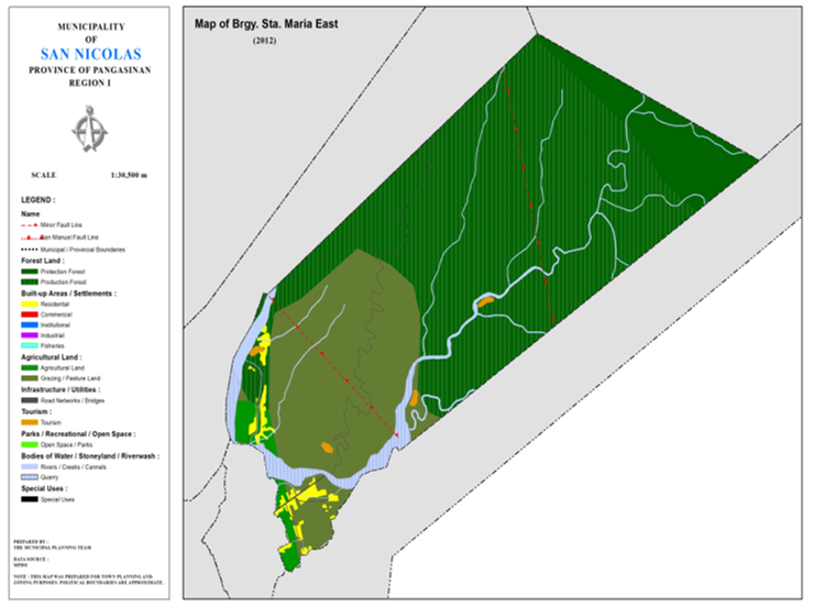
Status of Land classification (has.):
|
Existing Land Uses |
Area (has.) |
|
Protection Forest |
121.150 |
|
Production Forest |
875.280 |
|
Grazing/Pasture Land |
371.910 |
|
Agricultural Land |
27.530 |
|
Ambayoan River |
9.170 |
|
Cabalisian River |
14.980 |
|
Quarry |
40.790 |
|
Residential |
21.110 |
|
Institutional |
0.002 |
|
Tourism |
3.930 |
|
Cannals |
0.230 |
|
Creeks |
6.410 |
|
Road Networks |
2.110 |
|
Total Land Area |
1494.602 |
Major River : Ambayoan, Cabalisian River
Soil Type : Annam Clay Loam, Umingan Sandy Loam
SOCIAL PROFILE
|
Social Profile |
|
|
Total Pop. (NSO 2020) |
2,029 |
|
Annual Growth Rate |
2.81 |
|
Pop. Density |
1 |
|
No. of Households (CBMS 2020) |
497 |
|
Ave. Household Size |
5 |
|
Sex Ratio (Male/Female) |
103:100 |
|
Public Buildings / Facilities |
|
|
Barangay Hall |
1 |
|
Elementary School |
|
|
High School |
|
|
Rural Health Station |
|
|
Brgy. Health Center |
|
|
OSCA Building |
|
|
Brgy. Daycare Center |
1 |
|
Church |
ü UCCP ü UECDFI |
|
Brgy. Cemetery |
|
ECONOMIC SECTOR
|
Economic Sector |
|
|
Agricultural Production |
corn, palay, vegetable |
|
Livestock/Poultry Production |
|
|
Existing Industries |
|
|
Tourist Attractions |
water falls (potential) |
INFRASTRUCTURE AND UTILITIES
|
Infrastructure and Utilities |
|
|
Transportation |
motorcycle, tricycle, jeep |
|
Telecommunications |
sun, globe, smart |
|
Postal Communication |
|
|
Power and Electrification |
PANELCO III |
|
Water Supply and Irrigation |
|
|
Potable Water Supply |
Level I, Level III |
|
Post Harvest Facilities |
|
|
Slaughterhouse |
|
|
Market |
|
BARANGAY OFFICIALS:
|
BARANGAY OFFICIALS |
||
|
Position |
Name |
|
|
Punong Barangay |
FRANCISCO CARTUIZA FLORENTIN |
|
|
SBM 1 |
PEDRO MINGUA ABALOS |
|
|
SBM 2 |
REY ONTIMARA NAVORA |
|
|
SBM 3 |
MILAGROS CRISPINO RUBIO |
|
|
SBM 4 |
ANTONIO JAMANDRE GASCON |
|
|
SBM 5 |
MERCEDES IGNACIO BODOY |
|
|
SBM 6 |
VHERNIE TUBERA BATAAN |
|
|
SBM 7 |
RODOLFO VELASQUEZ MINGUA |
|
|
SK Chairperson |
|
TYRONE CRISPINO ALBERTO |
|
Barangay Secretary |
MARIVIC VELASQUEZ MINGUA |
|
|
Barangay Treasurer |
MICHAEL ANTHONY CRISPINO NAVORA |
|

